ViECam

28-08-13

Home
Su
ViECam
Clouds Detector
All Sky Cam
Sky Quality Meter


In meteorology, visibility is a measure of the distance at which an object or light can be clearly discerned. It is reported within surface weather observations and METAR code either in meters or statute miles, depending upon the country. Visibility affects all forms of traffic: roads, sailing and aviation. Meteorological visibility refers to transparency of air: in dark, meteorological visibility is still the same as in daylight for the same air.

We are trying to simulate the Human Visibility, we are not testing another visibility sensor that gives Sensor Equivalent Visibility. Read this page to understand the differences: Visibility

We are using

hardware

ViECam
Visibility Estimation by digital Camera


Edges of the current image
The system is under calibration and works only during daytime.

Please refresh the page to update the image and the visibility value.

The values are updated every 5 minutes


Reference image

How it works

The ViECam technology is based on an algorithm dedicated to the images analysis which emulates the human eye behaviour and to measure visibility, analysing the contrast in respect to the background of objects placed at a known distance.

ViECam is based on the following subsystems:
• Recording System (standard CCD/IP camera)
• Data Calculator

The ViECam system core is represented by a powerful algorithm that is able to elaborate single images recorded by recording systems and to calculate the main following parameters:


• Horizontal visibility
• Visibility between two points
• Fog thickness
• Phenomena tendency indicator (increasing or decreasing )


Edges of the reference image

 
TIME ON THE GRAPH IS UTC

NOTE:

On  December  14th 2012, T.R.S. SpA started in Vigna di Valle the on site trials of the ViDI (Visibility detection by Digital Images) System in collaboration with ReSMA ((Reparto Sperimentazioni di Meteorologia Aeronautica depending from the Centro Nazionale di Meteorologia e Climatologia Aeronautica dell’Aeronautica Militare).

The trials aim at the validation of the ViDI system  through the comparison of  the visibility measures  with the values observed by the operators of the local meteo station.

---> VIDI <---

Abstract of the
Training Guide in Surface Weather Observation
U.S. National Weather Service

VISIBILITY

Because it affects pilots approaching or departing your station, visibility is one of the most important
elements in the METAR observation. Make the visibility report descriptive of the actual conditions at
your point of observation.

Visibility is the greatest horizontal distance at which selected objects (visibility markers) can be seen
and identified. At times, however, you will be called upon to estimate visibilities for which you have
no markers. Base the estimate on the sharpness with which the most distant markers can be seen. If the
markers can be seen clearly, with little loss of colour, and with sharp outlines, it means that the visibility
is much greater than the distance to the markers.

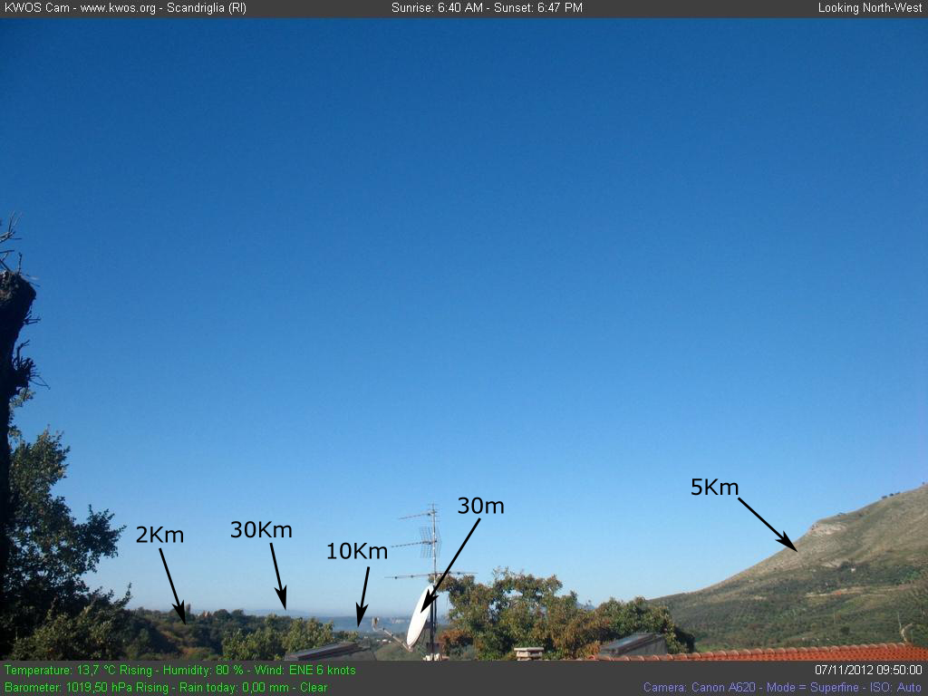
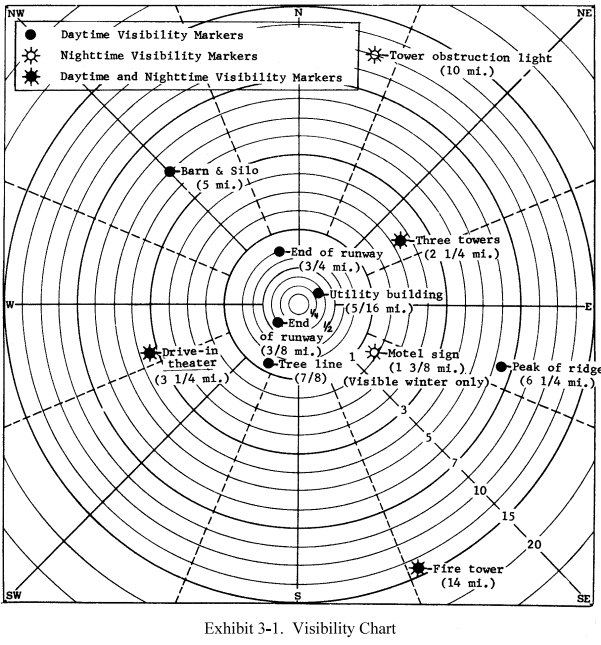
3.3 Visibility Chart
As an aid for determining visibility around the station, all stations are required to have a visibility chart.
And to be most useful, this chart should be posted near the point from which you observe visibility. This
chart should list or otherwise indicate the location of all visibility markers, their distance from the
station, and whether they are daytime or nighttime markers. It is also very important that this visibility
chart be kept current. An example of the type of visibility chart used is shown in Exhibit 3-1.

Although it is not required, it is useful to have a set of pictures of the visibility markers handy for ready
reference. Pictures can be helpful to new observers.

OUTLINE
DETERMINING VISIBILITY

From an outside point where all appropriate visibility markers can be observed:
1. Determine the most distant object visible, using the station visibility chart as a guide.
2. Estimate the visibility in the direction of this object as follows:

a. If the object is barely identifiable, consider the visibility to be the same as the distance to this object.
b. If the outlines of the object are in sharp relief, estimate the distance that can be seen
beyond this object.

                                                                                                                                                    #

Home | ViECam | Clouds Detector | All Sky Cam | Sky Quality Meter

Ultimo aggiornamento:  28-08-13